
Browser Panel: Data Management and Bookmarks
What you'll learn
- Handy features of the Browser panel
- Data management in the Browser panel
- An overview of spatial bookmarks and how to use them
Recommended for
- Anyone who manages data by moving back and forth between multiple folders and files
- Anyone who wants to check the CRS and attributes before loading data to reduce rework
- Anyone who manually zooms back to their usual scales and extents every time
Introduction
Many people use the Browser panel mainly for XYZ Tiles connections that provide basemaps, but it has plenty of other handy uses. This article shows how to get the most out of the QGIS Browser panel and make everyday QGIS work easier.
This article does not cover how to set up an XYZ Tiles connection. The following article explains it in detail.
What is the Browser panel?

The Browser panel is a QGIS panel that lets you move around the file system easily and manage geospatial data. Besides shared folders and GeoPackages, it gives you access to databases such as SpatiaLite, PostgreSQL, and Oracle, and to web connections such as WMS, WMTS, and XYZ Tiles. It also supports STAC (SpatioTemporal Asset Catalog), so you can handle a wide range of data sources in one place.
The panel shows only resources that QGIS can handle, which makes the data you need easy to find. You can also check data before loading it, and export, rename, or delete files, directly in the Browser panel.
By default, the panel appears at the top left of the QGIS window. You can move it or hide it to suit your work.
Useful features of the Browser panel
Project Home
When you save a project, QGIS creates a special item called Project Home. It works like a shortcut to the folder that holds the open QGIS project (.qgz / .qgs).
For example, if you keep the project file and its data together in the same parent folder, Project Home automatically points to that folder even when you open the project on another PC or in a shared folder, which makes it easy to hand projects over within a team.
The example below shows a project file saved as data_viewer and the administrative area layers for six Kanto prefectures, obtained from the National Land Numerical Information Download Service and saved in the same folder. When you open the data_viewer project in QGIS, Project Home appears in the Browser panel, and you can reach the data in the same folder as the project file from there.

You can also right-click the Project Home folder and select Set Project Home from the menu to specify any folder.
The New menu lets you create a new directory (folder), GeoPackage, or Shapefile, and even an ESRI FileGeodatabase, which commercial GIS also uses.
Folder filter and favorites
Finding a file is hard when one folder holds a large number of files. In that case, click the Filter Browser button at the top of the Browser panel, then enter a keyword in the search bar that appears to narrow down the tree.
Enter part of a file name, such as road or 2026, and only the matching data remains. You can also match case or use wildcards or regular expressions as options.
For example, if your naming rule ends every line data file name with _line, searching with a wildcard such as _line.shp narrows the list to the line data only.

Besides filtering data and folders, you can right-click a folder you use often and select Add as a Favorite. You can then reach the folder without searching for it every time.


Check and work with data
Check and manage the contents of a GeoPackage
A GeoPackage (.gpkg) can store multiple layers in a single file and manage both vector and raster data. However, it is hard to tell what a GeoPackage contains until you add it to QGIS.
In the Browser panel, click the arrow to the left of the GeoPackage to expand it and see what it contains before you load anything. A GeoPackage can hold a large amount of data, so loading it into QGIS just to see what is inside can get in the way of your work.
To add data, double-click or drag only the layers you need from the Browser panel into QGIS. You can also select multiple layers and add them at once.

For details about GeoPackage and how to add data by dragging and dropping from the Browser panel, see the following article.
Preview layers
After adding a layer to QGIS, you probably open the layer properties to check the coordinate reference system (CRS) and encoding, and open the attribute table to see what information it holds, before you start analysis.
But when you actually add data to QGIS, the CRS may be undefined, or the attribute table may be garbled and unreadable. Many people have gone back and forth between a data portal and QGIS after discovering such a problem only after adding the data. Some have also not known the extent of the data, and watched the map jump far away from the view they were working in the moment they added it.
To avoid this, right-click the data you want to add in the Browser panel and open Layer Properties. There you can check the metadata, attributes, and data extent before adding it.
The Metadata tab shows the same information you would see on the Information tab of the layer properties after adding the layer to QGIS, but before you add it. You can also check the CRS definition and encoding here, so you can go through everything that concerns you before adding the data.

The Preview tab shows the extent of the data. The image below shows administrative area data for Tokyo obtained from the National Land Numerical Information Download Service, and you can see at a glance that it includes the outlying islands.

The Attributes tab shows up to 100 rows of attribute data. Within the rows shown, you can sort in descending or ascending order, just as in the attribute table.

Work with data
After you check the metadata, CRS, and encoding, you may want to fix any problems or convert the data to the format you need before adding it to QGIS. The Browser panel does more than show information about folders and data. It can also edit data.
For example, right-click data and open the Manage menu to rename or delete the data. Open data often has romanized Japanese file names, and it can be hard to tell at a glance which dataset is which. Tidying up the names beforehand makes the work after adding the data easier.

The Export Layer feature opens the same dialog as Save Vector Layer as, where you can convert the data to any file format and change the CRS and encoding.
You can also add the layer to QGIS first and export it from there, but converting it beforehand saves you from fixing the format and settings in the Layers panel, so your work goes more smoothly.

Use the Browser (2) panel
When you show or hide panels and toolbars, you may have noticed that there is a Browser (2) panel in addition to the Browser panel. Even if you know it exists, few people may have actually used it.

You rarely need the second Browser panel in everyday work, but it helps when you want to see two folders at once, such as when you merge Shapefile layers into a GeoPackage.
For example, show the GeoPackage in Project Home in the first panel, and open the folder that holds the Shapefiles in the second panel. When you finish with one source folder, you can switch only the second panel to the next source folder and keep working.

Spatial bookmarks
What are spatial bookmarks?
Spatial bookmarks let you record a specific extent of the map as a “bookmark” and recall it instantly later.
QGIS can save spatial bookmarks in two ways. If you save a bookmark to your user profile under User Bookmarks, you can use it in any project you open. If you save it per project under Project Bookmarks, QGIS stores the bookmark in the project file, so the same bookmark is also available when you share the project with other users.

If you register the scales and extents you use often as bookmarks in advance, you no longer have to adjust the position and scale by hand each time, and you can jump straight to a registered extent whenever you need it. This is especially useful when you create layouts at multiple scales or frequently check a specific area in a project.
Register a spatial bookmark
This example uses a project that shows the administrative area layer of Tokyo and registers a spatial bookmark that displays Chiyoda ward at the center at a scale of 1:500,000.
- Adjust the map display.
- In the Browser panel, right-click Spatial Bookmarks and select New Spatial Bookmark. You can also click the New Spatial Bookmark button in the toolbar.

- In the dialog that appears, set the following items.
- Name: Enter any name. Use an easy-to-recognize name such as
千代田区_50万分の1(Chiyoda ward, 1:500,000). - Group: Enter any name. Set this if you want to group bookmarks.
- Extent: The default is the extent of the current map canvas.
- Saved in: Select Project Bookmarks or User Bookmarks from the dropdown.
- Click Save.
- Name: Enter any name. Use an easy-to-recognize name such as

Use and manage spatial bookmarks
You can see the registered spatial bookmarks as a list under Spatial Bookmarks in the Browser panel. You can also manage them in the Spatial Bookmark Manager panel, which gives a better overview. To show the panel, right-click the toolbar and check Spatial Bookmark Manager.

To move to a registered bookmark, double-click it. The map immediately moves to the extent you set.
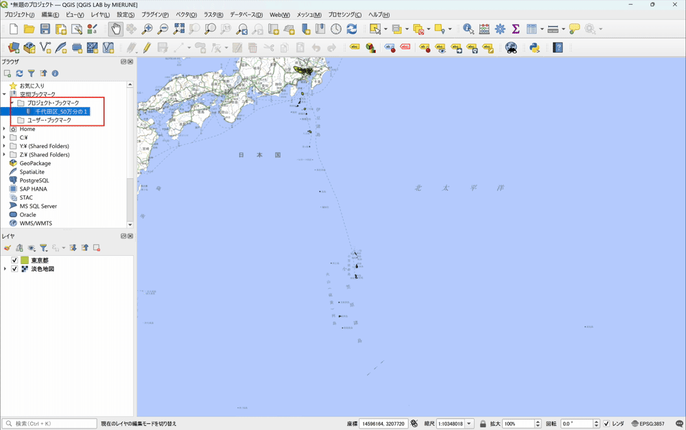
To edit or delete a saved spatial bookmark, right-click it and select the operation you want from the menu.

Conclusion
With Project Home, the filter, and favorites, the Browser panel helps you find the file you need quickly. Before you add data to QGIS, you can check its metadata, attributes, and extent in the preview. The panel also converts file formats, so you can organize your data before moving on to visualization and analysis.
Beyond finding and working with files, you can place two panels side by side to organize more easily and manage map extents with spatial bookmarks.
Try out the features of the Browser panel.
Data sources
- Created by processing “National Land Numerical Information (Administrative Area Data)” (Ministry of Land, Infrastructure, Transport and Tourism)

QGIS LAB is a comprehensive information hub for QGIS, the open-source GIS software. Under the concept of “Geospatial for Greater Good,” we share the knowledge and skills to open up the world through location data.


