
Little-Known Useful Features in QGIS
What you'll learn
- Useful features that are not commonly used
- Geocoding and Easter eggs
Recommended for
- Anyone who wants to use the handy features of QGIS
Introduction
This article introduces some little-known useful features in QGIS: geocoding and Easter eggs.

Geocoding
The QGIS window has a search area (the Type to locate box) at the lower left. You can use it for geocoding (place name search).

Enter > and then a text string to run a search and display the results (note that you need a space after >!).


Double-click the result you want in the list, and the map canvas moves to that location.
Geocoding appears to use a Nominatim server run by the community. Enjoy the convenience, but avoid putting too much load on the server.
Easter eggs (bonus features)
This section introduces Easter eggs that you can trigger by entering specific text in the Coordinate box at the bottom of the QGIS window.

World map
Enter world and press Enter to add a polygon layer of the world's continents. It appears to use data from Natural Earth. It includes country names, ISO codes, and more, which is handy!

Contributor locations
Enter contributors and press Enter to show the locations of QGIS contributors (it would be great to contribute enough to appear here).

Hackfest locations
Enter hackfests and press Enter to show where the QGIS Hackfest has been held.

Map puzzle
Enter bored and press Enter to switch the map canvas to puzzle mode! (If you get tired of working, a puzzle is a nice change of pace...)

Retro
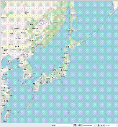
Enter retro and press Enter to give the map canvas a lo-fi look.

dizzy
Enter dizzy and press Enter, and... the map shakes (play a prank on a friend's QGIS and give them a scare!).
Conclusion
The features in this article came up in conversation within the company, and that is how we first learned about them. We wanted to share them with everyone, so we wrote this article. A few are just for fun, but a playful spirit matters no matter what you do!
We will keep sharing interesting information about QGIS!

QGIS LAB is a comprehensive information hub for QGIS, the open-source GIS software. Under the concept of “Geospatial for Greater Good,” we share the knowledge and skills to open up the world through location data.


