
Web Feature Editing for QGIS Data in Kumoy
What you'll learn
- What you can do with Kumoy's web feature editing feature
- The benefits of making QGIS data easier for a team to share and update
- Concrete ways to use it for field checks, internal review, and sharing with stakeholders
Recommended for
- Anyone who wants field staff and stakeholders to update data created in QGIS
- Anyone who wants to share and update information on a map smoothly with members who do not use QGIS
- Anyone who wants to reduce file handoffs and correction requests and manage the latest data as a team
Introduction
When you share maps and data created in QGIS with a team, you sometimes need to record what you learned in the field as a note, add a survey point, or make a small correction to the position or attributes of an existing feature. If every small update requires a correction request or a file handoff, it takes time to get from checking to applying the change.
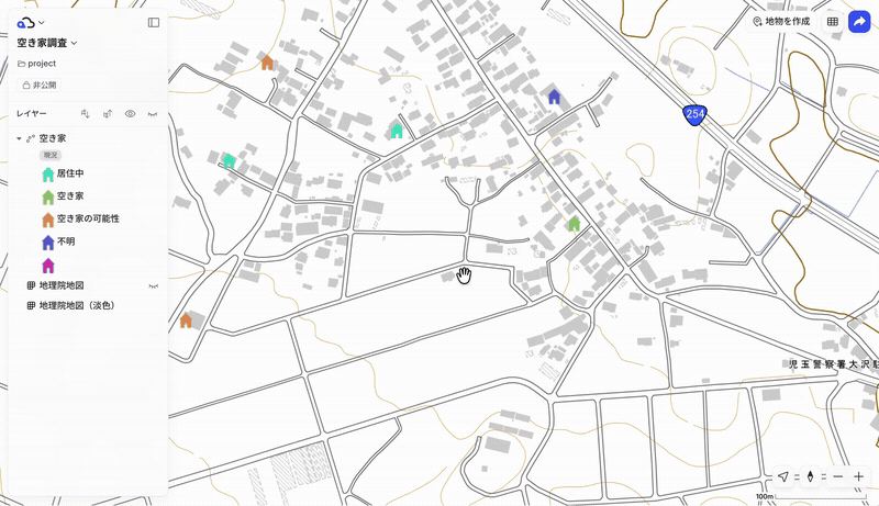
With Kumoy's feature editing, you can share vector data stored in Kumoy on the web and, in the browser, update attributes and delete features. On point layers, you can also add features and correct their positions. You do not need to open QGIS: you can look at the same web map and apply what you notice on the spot.
This article gives an overview of the web feature editing feature, in the context of a team sharing and updating the same data in Kumoy, and shows how it can be used for field checks, internal review, and sharing information with stakeholders.
What is Kumoy's web feature editing feature?
Kumoy's web feature editing feature lets you edit vector data shared in Kumoy directly from a web browser. It is available on the Business plan or higher.
On the web, you can mainly make the following edits:
- Add new features (point layers only)
- Correct the position of existing features (point layers only)
- Delete features you no longer need
- Change the attribute values linked to features
After you share data created in QGIS on Kumoy, stakeholders can look at the same web map and make the updates they need. During a field survey, you can add a feature from a smartphone. While reviewing the web map in the office, you can fix an attribute error you notice on the spot.
Of course, QGIS is better suited to detailed data creation and complex editing. But if small position corrections, attribute updates, and notes added after a field check can be finished on the web, the workflow gets much lighter.
Benefits of updating the same data as a team
Fix things on the spot without opening QGIS
When a team uses the same map data, the big appeal of web feature editing is that you can check the map in a browser and fix it right there.
For example, suppose you notice while checking the web map that “this point is slightly off,” “I want to update this facility name,” or “I want to change this to the surveyed status.” You do not need to launch QGIS separately and reopen the data.
During field surveys, too, you can look at the map on a smartphone and fix what you notice on the spot, which cuts the effort between checking and correcting.

Reduce back-and-forth on checks and corrections
In GIS work, the people who want to check the map are sometimes different from the people who can edit data in QGIS. In the traditional approach, reviewers tend to report what they notice by chat or email, and the QGIS person reads the message and edits the data. Even for a position shift or an attribute fix found in the field, if you have to take it back, sort it out, and send a correction request later, it takes time from checking to applying the change.
When you can edit features and attributes on the web, stakeholders who are not used to operating QGIS can more easily take part in updates to the extent they need. For example, field staff can enter the results of a check into the attributes during the survey, and managers can update the status and notes. Instead of going back to the office, reviewing notes and photos, and asking the QGIS person to make the changes, you can more easily reflect what you learn in the field on the map right there.
If the person who checked can update what they can fix on the spot, there are fewer correction requests, and QGIS staff can concentrate on more specialized data preparation and analysis.

Update the same data and share the latest version easily
Editing the same data in Kumoy on the web makes it easier to share updates across the team.
When files are copied and distributed, it can become unclear who updated which file and which one is the latest. If you instead refer to and update the same data in Kumoy, the team finds it easier to work while looking at the same data.
Because you can bring the whole flow of “viewing the map,” “checking the content,” and “updating as needed” into Kumoy, team map operations become simpler.
Examples of team use
Updating field check results
In field surveys, you often need to reflect information you learn on site, such as survey point locations, check status, notes, and information for managing photos, on the map afterward.
With web feature editing, field staff can open the map in a browser on a smartphone or tablet, update the attributes of a target point, or add a newly confirmed point. Instead of asking the QGIS person to add data, you can first leave what you learned on site on the map.

Maintaining facility and equipment information
It also suits work where you keep updating information on a map, such as facility registers, equipment management, inspection targets, and candidate site lists.
For example, if you manage equipment status with values such as “Unchecked,” “Checked,” and “Action needed,” the person in charge can update the attributes while looking at the web map. It is convenient that you can update with location and information kept linked, instead of managing the map and a table separately.
Internal review and sharing with stakeholders
When you share data created in QGIS inside your company or with stakeholders, being able to update what you notice directly on the web map makes checking and correcting smoother.
For example, you can make minor fixes on the web, such as inconsistent name spellings, classification corrections, deleting unneeded points, and small position adjustments. Without handing over a QGIS project or data files, you can share the data as a Kumoy web map, and the other person can check the map in a browser.
Tips for using it as a team
Decide who can edit
Web feature editing makes it easier for stakeholders to take part in updates, but it is also important to sort out who can edit what.
With Kumoy's organizations, teams, and roles, you can separate the people who view, the people who edit, and the people who manage. It is reassuring to design the division of roles in advance: field staff can edit only the data they need, reviewers mainly check, and administrators manage everything.

To learn more about Kumoy's organization management feature, see this article as well.
Set editing rules
When several people work on the same data, it helps to decide in advance what can be edited, when to update, and how to enter attributes.
For example: assign editors by area of responsibility, unify the options for status, and decide what goes in the notes field. Because anyone can edit on the web, it is important to prepare so that the whole team can update without hesitation.
Combine with QGIS for full-scale data preparation
Web feature editing suits situations where you check and update quickly. Complex editing and data preparation, on the other hand, are better done in QGIS.
With Kumoy, you can create a cycle: share data created and prepared in QGIS on the web, then use the updates collected on the web in QGIS again. By connecting QGIS and the web, the whole team, not just GIS staff, can make better use of the map.
Conclusion
With Kumoy's web feature editing feature, you can share vector data created in QGIS with a team and check and update it in a browser. Without opening QGIS, you can change attributes, delete features, and, on point layers, add features and correct positions, which smooths the flow from checking to correcting.
This is not simply a feature for “editing on the web.” It is a feature that lets people looking at the same map update the information they need on the spot. By creating and preparing data in QGIS and sharing it with Kumoy, the whole team can make better use of map data.
For detailed steps, see the Kumoy manual page.

QGIS LAB is a comprehensive information hub for QGIS, the open-source GIS software. Under the concept of “Geospatial for Greater Good,” we share the knowledge and skills to open up the world through location data.


